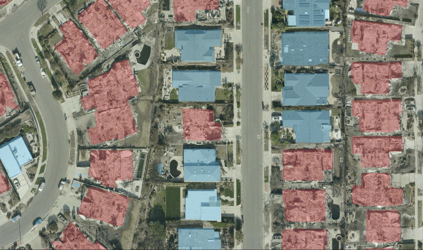
The 2025 Los Angeles wildfires created an unusually hard transfer test for MBCTD. I had trained the model on ordinary building changes in France: construction, demolition, and buildings that remained in place between aerial surveys. It had never seen the Palisades or Eaton fire areas, and it had not been trained to recognize fire damage.
I wanted to answer a narrower question than whether it could become a wildfire-damage model: could its learned representation of structural disappearance provide useful first-pass evidence without retraining?
Turning building change into a damage hypothesis
MBCTD produces three dense masks from a before-and-after image pair: unchanged buildings, demolished buildings, and new buildings. For this experiment, I interpreted those outputs in the disaster context:
UNCHANGEDbecame evidence for an intact structure.DEMOLISHEDbecame a candidate for a destroyed structure.NEWindicated construction or rebuilding after the 2024 baseline.- Overlapping demolished and new predictions indicated replacement.
That mapping is deliberately cautious. A building absent after a fire may have been destroyed, but the model predicts visual change rather than cause. It does not know whether fire, planned demolition, imagery quality, or registration produced the difference.
Comparing the same neighbourhood across time
I used high-resolution aerial imagery provided through LA County’s LARIAC program and served through Pictometry. The 2024 layer supplied the pre-fire baseline. The comparison layers included January 2025 imagery for the Palisades and Eaton fires, followed by post-fire surveys from July through October 2025.
This created two useful comparisons. The January imagery shows the immediate transition from buildings to debris or cleared footprints. The later layers show what happened next: sites can remain empty, be cleared more completely, or begin reconstruction.
I built an interactive map around the experiment so every prediction could be checked against its source imagery. I could swipe between dates, change their opacity, draw a neighbourhood or individual block, and run MBCTD only inside that region. The selected imagery was assembled from map tiles and processed in overlapping patches before the masks were returned to their geographic position.
The interface was not the result by itself. Its purpose was to keep the evaluation inspectable: a coloured mask only mattered when the before-and-after evidence underneath it supported the same interpretation.
What transferred
Complete structural loss was the clearest success. Where a recognizable roof and building footprint in 2024 became rubble or an empty parcel in 2025, the demolished channel often produced a coherent response over the former structure. Intact neighbouring roofs were frequently retained as unchanged, so the model could separate heavily affected parcels from surviving buildings within the same block.
The temporal setup also helped distinguish destruction from later activity. A site could be identified as demolished in the January comparison and appear as new or replaced when a later 2025 layer showed construction. That is more informative than treating every visible difference as a single undirected change.
These results are consistent with the task MBCTD originally learned. A completely destroyed building is visually close to demolition: a stable structure disappears between the two dates. The model transferred best where the wildfire outcome resembled that familiar transition.
Where the transfer broke down
Partial damage exposed the limit of that analogy. A burned or damaged building can keep most of its footprint and roof geometry, even when it is unsafe or unusable. MBCTD was not trained on severity labels, so subtle roof damage and partially standing structures could remain classified as unchanged.
The model also reacted to differences that were not damage. Shadows, vegetation loss, debris, temporary objects, colour shifts, and small alignment errors can all alter the temporal signal. Lowering the prediction threshold increased sensitivity to possible destruction, but it also admitted more of this noise. The map therefore used a deliberately sensitive threshold for exploration, not a calibrated probability of fire damage.
Most importantly, this was a qualitative zero-shot evaluation. I did not have an expert-reviewed, pixel-aligned damage mask for the inspected LA imagery, so there is no wildfire precision, recall, or F1 score to report. The outputs show where the pretrained model transferred plausibly and where it failed; they do not establish operational accuracy.
Conclusion
MBCTD transferred because complete wildfire destruction and ordinary demolition share a strong visual event: a building disappears. That was enough to produce useful candidate masks in unseen Los Angeles imagery without retraining. It was not enough to make the model a general damage assessor.
The honest use for this system is prioritization and visual review. It can direct attention toward likely structural loss and keep the evidence tied to the underlying dates, but a person still has to verify each location. Partial damage, cause, habitability, and confidence all require information the model does not provide.
A proper wildfire model would need expert damage labels, severity classes, geographically separated evaluation areas, calibration against the target imagery, and uncertainty reporting. This experiment provides a concrete baseline for that work—and a clear account of which parts of the original building-change task survived the domain shift.